Key takeaways:
- Southern California is bracing for potential deluge of rainfall from Hurricane Hilary this weekend
- Rainfall amounts of 2 to 4 inches, and isolated amounts in excess of 8 inches stretching from southern California to southern Nevada
- Peak impacts are expected Sunday and Monday, with potential for significant flash flooding and damaging wind gusts
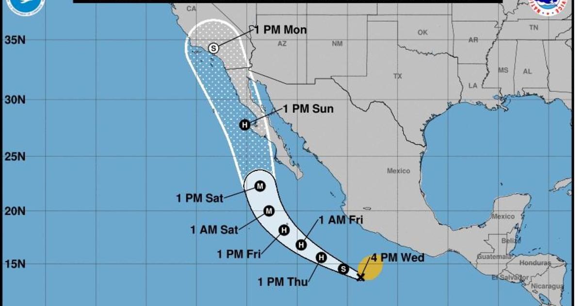
Southern California is bracing for a potential deluge of rainfall this weekend as Hurricane Hilary makes its way up Mexico’s Baja California peninsula. Forecasters said the storm is expected to produce 3 to 6 inches of rainfall, with maximum amounts of 10 inches, across portions of Baja California through Sunday night, with the possibility of flash flooding.
The storm is expected to hit Southern California with heavy rainfall as early as this weekend, with rainfall amounts of 2 to 4 inches, and isolated amounts in excess of 8 inches stretching from southern California to southern Nevada. As of Thursday afternoon, Hurricane Hilary was located about 475 miles south of Cabo San Lucas, Mexico, with sustained winds of 85 mph.
While some wind impacts are likely for areas in the path, the rainfall will be the greatest risk. Los Angeles averages 0.00 inches of rain for the month, and San Diego just 0.01 inches. That would be a stunning amount of rainfall for the month of August, the driest month of the year across this region.
The peak impacts are expected Sunday and Monday, when significant flash flooding may occur. Greg Postel, a hurricane and storm specialist at the Weather Channel, told CBS News that there will likely be “damaging wind gusts,” especially at higher elevations, in the area, and swells along the coast.
Residents of Southern California are advised to take precautions and prepare for the potential of heavy rainfall and flooding. The National Weather Service is monitoring the storm and will provide updates as the situation develops.


Be First to Comment